
The Foresight Centre created a map application of the Estonian school network
The Foresight Centre created a map application of the Estonian school network, where you can see where Estonian schools are located and where children live. The application also shows the main indicators of general education schools for the last five years and a simulation of the schools’ futures based on today’s birth rates.
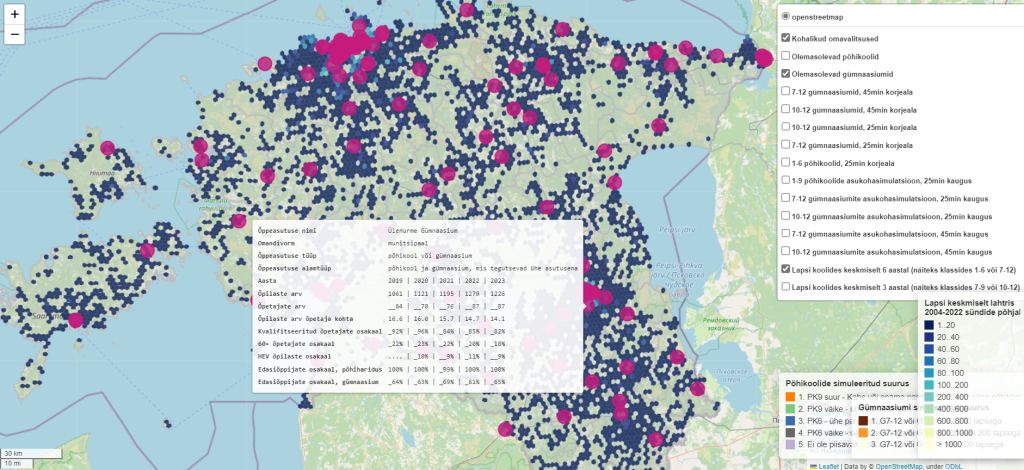
You can use the new map application (in Estonian) to view the schools’ most important indicators, such as the number of children and teachers and their age and the proportion of qualified teachers in the school. You can also see where children are located in relation to the school, i.e. how many children live within a 25- or 45-minute drive from the school.
According to Eneli Kindsiko, expert at the Foresight Centre, this is the first time we’ve been able to get such a comprehensive picture of the Estonian school network. “The Estonian school network was largely established decades ago, when the birth rates were significantly higher than today and schools were set up mostly where the population lived then,” said Kindsiko. “Today, however, both the location of the population and the administrative boundaries of local governments, i.e. school administrators, have changed.” Kindsiko added that modernising the school network means that decisions need to be made for several decades ahead. “Ensuring the best educational future for children, regardless of where they live, must be the top priority,” she said.
The map application of the Estonian school network shows, for example, that there are overlaps in some regions, i.e. the children in areas where their numbers are decreasing belong to the catchment areas of several schools. In other regions, however, we can see that there are not enough schools.
The map application allows the user simulate the future of Estonian schools based on today’s births, i.e. how many children would remain in the catchment area of a particular school in the future and how big the school should be and where it would be sensible to establish it in that particular region.
Kindsiko pointed out that today’s secondary school graduates were born at a time when the birth rate in Estonia was nearly 15,000 children per year, but last year, fewer than 11,000 children were born, which is about 27% less. “The decline in the number of children is greatest in rural areas, which is why local governments across Estonia need new educational models to ensure that educational services would continue to be available in rural areas,” said Kindsiko. “All the more so that around 10% of Estonian teachers are at retirement age and we are at the top of Europe with this indicator. In Estonia, the regions with the most teachers at retirement age are Lääne, Rapla and Jõgeva counties.”
Therefore, Estonia’s challenge is both the decreasing number of pupils and not enough young teachers. The map application allows you to see how much local governments should cooperate with each other in school administration. “Estonia’s advantage is its small size, which is why we should be more quick in deciding and trying out new solutions for cooperation between local governments, primarily as an alternative to closing schools,” said Eneli Kindsiko.
The map application was created as part of the research stream ‘The future for the Next Generation of Teachers’. The research stream considers past trends and various possible future trends, as well as fundamental political decisions in matters related to the next generations of teachers and highlights the central uncertainties and key factors on which the succession of teachers in Estonia depend until the year 2040. The research report is available here: https://arenguseire.ee/uurimissuunad/opetajate-jarelkasvu-tulevik/
Find the map application of the Estonian school network here (in Estonian): https://arenguseire.ee/koolivorgu-kaardirakendus/
Latest news
-
26.03 2026Survey: The experience of intimate partner violence reduces trust in the police, courts and prosecutor's office
A survey commissioned by the Foresight Centre revealed that people trust the police and other state institutions much less when it comes to intimate partner violence than in other situations. At the same time, those who have been directly or recently exposed to violence trust women’s support centres and Victim Support (Ohvriabi) highly.